


 |
|||
|
Mountain trail |
Big Chelustyn |
Kok-su |
Kok-su |
|
Small Chelustyn |
IBEX |
Tien-Shan brown bear's feet print |
Campfire |


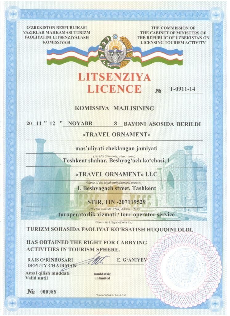
KOK-SU RIVER TREKKING

Itinerary: Tashkent - Ugam - Chatkal National Park: Yakkatut village - Koksu river - natural boundary Ayrik - Yakkatut village - Tashkent
Region: Ugam-Chatkal National Park, Western Tien-Shan, Uzbekistan
Tour duration: 5 days/4 hights
Season: May-October
Trekking distance: 54 km
Highlights: Trekking inside Ugam-Chatkal national park upstream Koksu river to the mountain lake. The wildness of the gorge, rocks steeply breaking from 1.5 km altitude to the bottom of a grandiose canyon cause undisguised admiration. Beautyfull mountain ridges with all the year round snow-covered peaks, high-mountainous lakes, mountain rivers and springs with pure water, shady groves and various kinds of trees and flowers.
Tour program:
 |
Day 1 Starting of tour to the mountain settlement Yakkatut (2 hrs, 100 km). Treking along the Koksu river to the place named Zambot. Camp #1 on the bank of Koksu river at the mouth of Zambotsay at the altitude 1166 m. Dinner near a fire place. Trekking distance - 14 km |
 |
Day 2 Continue of trekking through Koksu gorge. Wild nature, steep walls. The depth of the gorge-canyon is more then 1.5 km. Entrance to the natural boundary Ayrik. Camp #2 at the altitude 1390 m. Trekking distance - 10 km |
 |
Day 3 Day of rest. Excursion through the gorge of Ayrik river to Kichkinakul lake. Observing the fossils of sea animals and plants on the fragments of the rocks. Beautiful sight of Piyezak river. Trekking distance - 8 km Altitude of the lake - 1690 m |
 |
Day 4 Return transition to Koksu river's narrowing place between the rocks which is named "The jump of a snow leopard". Camp #3 on the bank of the river in the shady grove, near the stream at the altitude 1390 m. Trekking distance - 8 km |
 |
Day 5 Pass to Charvak water reservoir. The end of the route at the settlement Yakkatut. Transfer to Tashkent. Trekking distance - 17 km |
Inclusions:
- transfer Tashkent - Yakkatut village - Tashkent;
- Ugam-Chatkal National Park ecological fees;
- camping outfit (tents, sleeping bags and insulated mats, first aid kit, etc);
- FB meal (breakfast, lunch and dinner);
- rent of horses for carrying of camping outfit and meal;
- service of mountain English speaking guide, cook, drover;
- special permit to the nature conservation territory;
- registration and touristic tax.
Recommended outfit:
1. trekking boots;
2. trekking trousers;
3. windcheater.
4. thermo-underwear (spring/autumn season);
5. slippers;
6. headlamp;
7. personal first aid-kit;
8. toilet set.
Recommended UV protection:
1. cap;
2. sun block cream and sun glasses.
Weight restrictions:
*The weight carried in horses' bags are critical, therefore the trekkers have to keep the weight of personal clothing and other stuff to a maximum of 10 kg or lighter.
Permitting requirements:
1. The itinerary passes through the nature conservation area where the special permit demands. The documents for permitting should be submitted in 15 days before the tour.
2. Copies of the following documents are required for permitting:
- scanned copy of passport;
- scanned copy of entry visa.
Map of trekking route to Kok-su river

Trekking highest altitude - 1690 m
Trekking end altitude - 1004 m
Total trekking distance - 54 km
Trekking Photo Report July 2018
Useful links:
Hiking/Trekking in Uzbekistan
Outdoor adventure in Uzbekistan
